By Jae-Ha Kim
Chicago Sun-Times
February 16, 2003
ARCADIA, Mo.–When it comes right down to it, geocaching is just a high-tech version of hide and seek. Someone hides a box full of “treasures” in a public place–usually a park or forest–inputs the coordinates online at www.geocaching.com and then waits for people like you and me to go hunt for them.
With the help of a Global Positioning System receiver–a handheld navigational computer–you can do this at home or, if you’re feeling adventurous, at a new location you’ve never been to before.
Which brings my party of four to Missouri. We’re in the show-me state driving around Arcadia, a quaint little city about an hour south of St. Louis.
Armed with two GPS units and a couple of walking sticks (perfect for poking into crevices that may contain the geocaches), we track our first cache at Elephant Rocks State Park, which is just outside Arcadia at the northwest edge of Graniteville.
Geocaching (“geo-cashing”) is a sort of adventure hobby, a sport for techno geeks, with the “geo” standing for “geography” and the “cache” representing the treasure and the log book found at each site. During my first geocache outing in Chicago, I left a couple of moist towelettes as my treat. Thereafter deemed unworthy of tending to these treasure chests, I am not put in charge of the Missouri caches. Instead, my friends leave carefully thought-out trinkets that tie in to each cache’s theme.
For instance, at “Elephant Cache,” we leave a small ceramic elephant. It nestles in with the other treasures people have left: a couple of Harrah’s coins, batteries (which can come in handy if your GPS unit dies), dice, pencils and a couple of small bouncy balls. I eye the chewing gum but am convinced that taking something edible isn’t such a good idea. This particular cache was created a year ago; who knows how long the gum has been been sitting there.
Geocaching is a wonderful way to trick sedentary people into exercising. You get so caught up in the hunt you forget you’ve been walking briskly for a couple miles and may be just a little winded. You also get a bit euphoric finding one cache and are anxious to look for more, which is why it’s always a good idea to plot in a few extra coordinates for more caches than you’ll need.
Geocaching is a vigorous hobby for the winter. Trekking around in boots may be more challenging than hoofing it in sneakers, but cold weather has its pluses: There are fewer bugs and snakes to worry about.
Along the way to our second cache at Elephant Rocks, we explore a bit of the 129-acre state park. Famous for its amazing rock formations–some of which are believed to be a billion years old–the park is full of hikers of all ages who are enjoying a brisk walk on the trails. Highlights include a lake suitable for fishing, clean picnic grounds and a Braille trail for the blind.
By this time, we’re hungry. We head over to the Arcadian Cafe (123 Main St., 573-546-2432) for a quick lunch. The menu is as eclectic as the building, which dates back to the 1880s, when architect Louis Miller used it for his office. Bison apparently make it a big favorite with the locals. There are bison burgers ($6.50), bison Porterhouse steaks ($25) and bison top sirloin ($18). The chef also offers a frog leg platter ($15), wild boar ($25) and venison loin chop ($25).
When I see buffalo chunks ($5) on the menu, I’m not quite sure if they’re buffalo chicken wings or actual buffalo meat. I opt for a delicious vegetarian sandwich ($4.75) that is full of roasted peppers, portabello mushrooms and Swiss cheese. The chocolate mousse cake ($2.25) is to die for.
On our way to the next cache, we see the Arcadia Academy, an old Catholic girls’ boarding school that’s now an antique mall. Arcadia residents like to point out that Bob Hope’s daughter attended the school back in the day, when it was called Ursuline Academy.
In a few miles, we reach Taum Sauk Mountain State Park to tackle “Missouri’s Highest Cache.” The creator’s clues are accurate: “This cache is hidden right by the highest spot in Missouri. It is in a state park.”
Almost 1,773 feet later, we find the cache. We take none of the contents, but leave a small tool kit and a $5 gift certificate for the Arcadian Cafe that the proprietor gave us. By the way, if you happen to find the coupon and decide to try out the cafe, please write and tell me if the buffalo chunks are yummy.
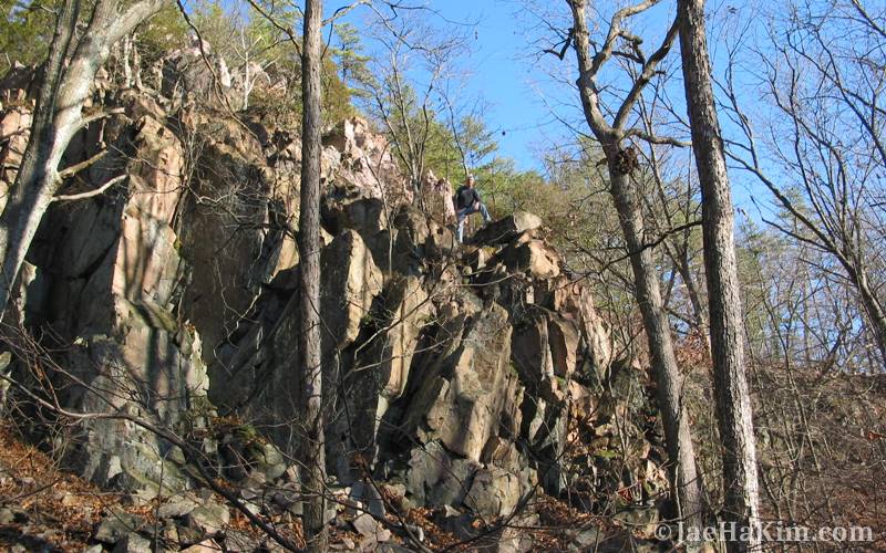
The fourth cache of the day proves to be the most challenging. On a scale of 1 to 5–with 5 being the most difficult–”Royal Pain” is rated 3.5. Located at the Royal Gorge Natural Area on Highway 21 just south of Arcadia, Royal Gorge features a cavernous canyon-like shut-in along the highway.
In order to retrieve this cache, you have to climb 30 feet above the forest floor on a bunch of precarious rocks. We scour the landscape for every little nook and cranny that may be hiding a plastic Tupperware case filled with treasures. We search for 1-1/2 hours. Just when we’re about to give up, we spot it. It’s hiding under a slab and sure enough, it’s about 30 feet above where we are.
I don’t relish the idea of rock climbing without belay, so we send Denton Morris, the most athletic member of our party, to fetch it.
By this time, we have nothing left to contribute to the cache except a sense of accomplishment, and we decide to take that with us.
Geocaching is a wonderful excuse to play around like a kid and explore. It’s also an amazing way to broaden your horizon outside your own little world. Chances are I would never have found Missouri, much less Arcadia, without it.
Specifically: For more information on geocaching, visit www.geocaching. com. For more on Missouri State Parks: www.mostateparks.com.
The ABCs of GPS
The beauty of geocaching is you can do it anytime and just about anywhere. Sure, snow and rain may make the hunt more challenging, but with a good Global Positioning System unit, you’ll do just fine.
A GPS unit can’t get you exactly to where you need to go, but it’ll get you close–within 6 to 20 feet of your desired destination. Plug the longitude and latitude coordinates into the unit, and it’ll figure out where you need to go, even if you’re map-challenged. It does this by locking onto at least three of the 24 satellites worldwide.
GPS units start as low as $99 and can run upwards of $1,000. For this trip, we relied on the Magellan Meridian Platinum ($399) and Garmin Etrex Vista ($375). Both have built-in compasses and maps that were accurate and easy to follow. You may download additional maps onto them as well. Picking which one you want basically comes down to personal preference and need.
The smaller, sleek Garmin definitely has a better look and easily fits into pockets. It operates like a cell phone, with side toggles to navigate the menu. It’s perfect for one-handed operation, though it can get a little confusing to navigate if you have large fingers.
The Magellan is shaped more like a remote control. The large viewing area is awesome and the button layout makes for easy, intuitive operation. Its receiver also was more sensitive than the Garmin, so we were able to lock onto satellites faster (20 to 30 seconds opposed to a minute or more) and in more difficult conditions (say, under big cliffs and heavy trees).
A few notes about caching: Think of it as a party. You’d never show up at someone’s house without bringing a little something with you. So while you’re invited to take a treat from the cache, it’s considered bad manners not to leave something in return. Just make sure it’s not food or anything illegal. Many families cache with little ones in tow, so make sure the items you leave are G-rated.
Finally, almost every cache includes a small notebook and pen or pencil. Fill it out so the person who created the cache knows you were there.